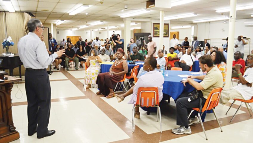
At a public meeting hosted by the Boston Transportation Department (BTD) last week, Roxbury residents, activists and local elected officials raised sharp questions about a plan to widen Melnea Cass Boulevard in order to add new center median bus lanes and stations.
A group called Friends of Melnea Cass Boulevard stretched a 40-foot string across the meeting room to illustrate how much extra width the new bus lanes will demand. The group’s members decried the expected removal of mature trees and the increased distance for pedestrians crossing the busy street.
“I don’t see how this is going to make the road safer,” said Yvonne Lalyre, a Lower Roxbury resident who held one end of the string. “Who wants a widened road in their backyard?”
The new bus lanes are part of an overall redesign plan for Melnea Cass Boulevard, under discussion since October, 2011. The BTD is the lead agency among a group of city and state agencies involved in the project, funded with roughly $9 million in federal and state money along with $600,000 in city of Boston funds. The intent is to integrate the goals of Boston’s “Complete Streets” initiative, the Roxbury Strategic Master Plan (RSMP), and the state-led Urban Ring project that includes a Bus Rapid Transit (BRT) corridor linking Roxbury and other Greater Boston communities.
The March 6 meeting was the fifth public meeting since project planning began in fall 2011. Patrick Hoey, BTD senior transportation planner and director of this project, has been moderating the meetings.
At previous meetings, the project’s team of transportation engineering, bicycle planning and landscape architecture experts explained the “Complete Streets” strategy, which adds pedestrian- and bicycle-friendly features. In small-group breakout sessions, there was wide agreement that Melnea Cass Boulevard is now inhospitable to pedestrians, poorly lit at night and a litter-strewn eyesore in some parts. Many consider the street a barrier separating the Dudley Square area from Lower Roxbury and the South End.
The project team also presented options for placement of new BRT lanes, either on the sides or in the center. Although the full implementation of the Urban Ring is currently on hold due to Massachusetts Department of Transportation (MassDOT) and MBTA funding shortages, the Melnea Cass redesign plans still incorporate dedicated bus lanes for future BRT service.
But many in the community only realized recently how much wider the street would have to be to accommodate everything, said Kay Mathew, a member of Friends of Melnea Cass Boulevard who recently co-authored a letter to local news outlets protesting the street widening.
“They never talked about widening,” she said after the meeting. “In all the talk about ‘complete streets,’ the elephant in the room was the addition of two more lanes. It’s now been made clear that that will be the impact.”
Project diagrams shown at the meeting and viewable online confirm a roughly 40-foot expansion of the street. The proposed design includes two traffic lanes in each direction, two center BRT lanes, a tree-lined center median, a street parking lane on some blocks, improved sidewalks and crosswalks and a bicycle-only path.
The full crossing distance on Melnea Cass Boulevard would be 108 feet. Compared to other center-median transit line locations, it would be shorter than Beacon Street at Coolidge Corner (111 feet) and Huntington Avenue near the Museum of Fine Arts (126 feet).
Regarding tree loss, project planners acknowledged that mature trees would have to be removed, but said new plantings would create a net gain of about 100 trees.
Under questioning about the necessity and purpose of the BRT lanes, Hoey said, “We were pretty much mandated by the [Roxbury Strategic] Master Plan and the Urban Ring to have the transit corridor. The idea is we’re building for the future.”
Even without BRT in place, he said, existing bus routes and possibly emergency vehicles could use the new lanes and make faster trips through the congested area.
After a number of puzzled and concerned comments about the BRT aspect, Boston City Councillor Tito Jackson asked if perhaps receiving federal funds was tied to building dedicated BRT lanes. Hoey did not have an immediate answer, but in a later e-mail said the funding does not depend on new BRT lanes. But he noted that the Roxbury Strategic Master Plan (RSMP), devised in 2004 with community input, states that any reconstruction of Melnea Cass Boulevard must incorporate both transit and bicycle facilities into its design.
Indeed, the RSMP stipulates BRT development to fit in with the state plan to create crosstown links (the Urban Ring) between existing Greater Boston transit routes.
“In the current thinking of the Urban Ring project, Melnea Cass Boulevard will become a Bus Rapid Transit (BRT) corridor,” the document states. “This connection would provide Roxbury residents access to more options for jobs, job training, retail, social and cultural facilities.” The RSMP says that BRT buses could run in mixed traffic, in exclusive lanes or in dedicated busways.
Some attendees wondered whether the “extra” land for the street project would come from the Madison Park housing area. Hoey said no property will be taken from Madison Park or any other owner; expansion will be on land already owned by the city or state.
State Rep. Gloria Fox, whose 7th Suffolk district includes a portion of Melnea Cass Boulevard, said that attendees in previous meetings had suggested a walking tour of the street to show local residents exactly what will happen where. The project team agreed to schedule a walk-through sometime this spring.
A widened street seems counter to the idea of reducing the barrier effect, several community members said.
“I don’t see how your plan fits into a neighborhood feel,” said Bill Singleton, a local resident and landlord. “I walk there now, and it feels like a commuter route. We want you to pay attention to the people who live there. We want to see that it’s not going to just be a widened, desolate area.”
Hoey agreed the boulevard feels like a highway now, but said the new accommodations for walkers and bicyclists will make it feel more like an urban neighborhood street. And better bus transit will attract more riders, helping to reduce vehicle traffic, he suggested.
He also noted that new developments in the works at Melnea Cass and Washington Street — including a hotel, ground-floor retail shops, offices, residences and a new, expanded Tropical Foods store — will add life to the area. New on-street parking options and more things to see and do will encourage people to stop, and should help to calm traffic flow.
“We’ve engaged one of the best traffic engineering firms in the nation,” he said. Efficient signal timing, improved crosswalks and the “pedestrian refuge” provided by the center median, he said, will make the street safer and better despite a wider crossing.
Besides Jackson and Fox, elected officials present at the meeting included state Rep. Byron Rushing, state Sen. Sonia Chang-Diaz, and staff members from the offices of At-Large City Councilor Felix Arroyo and U.S. Rep. Michael Capuano.
The next public meeting for the project is not yet scheduled. One upcoming step is a hearing with the Massachusetts Department of Transportation (MassDOT) sometime this summer, Hoey said. Design development will continue beyond that, and construction is expected to start in 2014 or 2015. For more information — including links to the RSMP, the Urban Ring plan, area development proposals, and meeting minutes and slides — see the project website: www.cityofboston.gov/transportation/melnea.
Also in Roxbury, Hoey is directing a BTD project to redesign traffic flow around Dudley Square. The second public meeting for that project was held on March 11. Attendees viewed several possible plans for streamlining bus and car traffic, making pedestrian crossings safer and adding more bicycling options and car alternatives such as Zipcar. Breakout sessions brought impassioned debate on the plans and a call for the city to create a comprehensive parking plan for the area. For more information on the Dudley Square project, see http://bostoncompletestreets.org/topics/whats-new.