
Author: (Banner photo)Sal Giarratani shows the approximate location of a mile marker he remembers from his childhood in Lower Roxbury. Many of Paul Dudley’s mile markers have been moved or broken.
Sal Giarratani remembers vividly the streets where he grew up in Lower Roxbury in the 1950s, although most of them are gone, deleted during the state’s push to create an inner belt highway where Melnea Cass Boulevard now runs.
Gone too is a relic of a more remote past: An 18th century obelisk-shaped granite mile marker Giarratani says once stood near the corner of Washington Street and Melnea Cass Boulevard.
“On one side there was a giant R and it said 1630,” Giarratani says, inspecting the corner lot where he says the stone once stood. “On this side there was a giant B and it said ‘miles to Boston.’”
The stone Giarratani describes may have been one of many erected by Paul Dudley, an attorney general and associate justice of the state’s Superior Court in the 1700s. His initials, PD, appear on granite mile markers and parting stones throughout those parts of Boston that were originally included in the town of Roxbury — West Roxbury and Jamaica Plain.
The distance was measured from Boston’s Town House, a local government office that stood where the old State House now stands on Court Street.
Most of the state’s mile markers were erected along what was once the Boston Post Road, a colonial-era highway linking Roxbury with Western Massachusetts, go as far out as Springfield. Many markers are still standing, although Dudley’s initials appear on few outside of Boston.
Dudley’s work in erecting the stones was an early public works project in the Massachusetts Bay Colony, paid for out of the jurist’s own pocket for the benefit of travelers. In a state where road and street signs are still often viewed as an afterthought, Dudley’s contributions of more than 200 years ago were quite progressive, notes Roxbury Historical Society President Thomas Plant.
“It’s certainly one of the first efforts to do anything like this in America,” he said.

Author: (Banner photo)Mile markers like this one in Grove Hall were erected to show the distance to the Old State House on Court Street. Like most in historic Roxbury, this marker, created in 1735, bears the initials of Paul Dudley. Colonial-era mile markers were laid along the Boston Post Road as far west as Springfield.
The stones also serve as a reminder of Roxbury’s boundaries, which have shifted several times since the settlement was chartered in 1630, along with Dorchester, Boston, Newtowne (now Cambridge), Dedham and Charlestown.
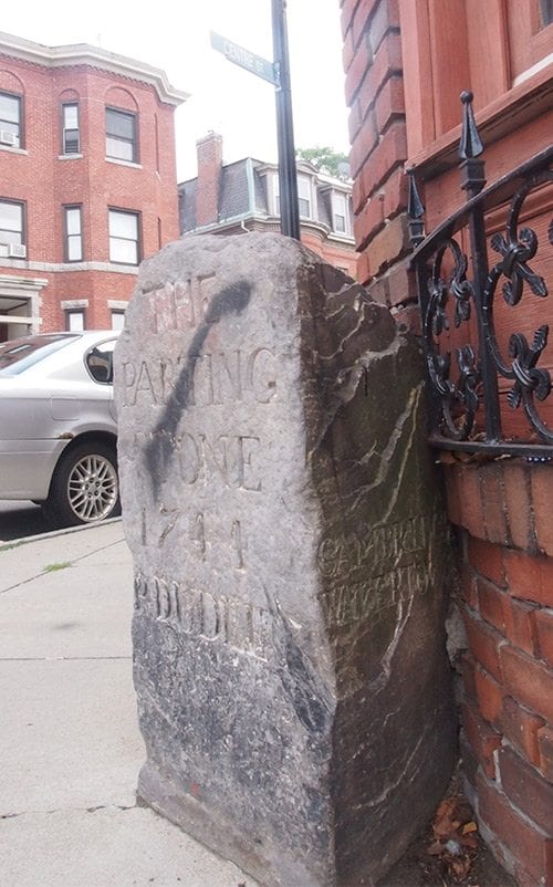
Dudley seems to have begun his public works project in the early 1700s. Perhaps the most famous of the markers, known as The Parting Stone in John Eliot Square, stood at the intersection of roads leading to Rhode Island via Dedham, Western Massachusetts via Cambridge and Boston.
Erected in 1744, the stone originally featured an iron post on which lamps could be hung. It now stands at the intersection of Roxbury, Dudley and Centre streets. Nearby on Centre Street is a three-mile marker, also bearing Dudley’s name.
In addition to marking mileage to Boston, The Parting Stone marked the departure point for stagecoaches heading for Boston from Roxbury. In those days, John Eliot Square served as a town square for Roxbury. The First Church of Roxbury and the Norfolk House Inn were important institutions in the town.
“If you were travelling to Boston in those days, you would stop overnight at the Norfolk House, freshen up, then make your entrance in Boston the next day,” Plant said.
The only remaining relics of that era still standing are the Dillaway Thomas House, an early 18th Century home that was later used as a headquarters for General John Thomas during the American Revolution and The Parting Stone, although newer versions now exist of the First Church of Roxbury and the Norfolk House (built in 1804 and 1853, respectively).
Boundary markers

Author: (Banner photo)This granite marker on Washington Street, originally erected in 1823, shows the boundary between Roxbury and Boston.
While parting stones and mile markers were prominent in the 1700s, granite stones marking Roxbury boundaries became prominent in the 1800s. State Rep. Byron Rushing notes that the northern edge of the town of Roxbury was delineated with one such marker in 1823.
The marker, which decades ago was broken at its base, still stands near the intersection of Washington and Ball streets. The boundary between Boston and the town of Roxbury extended from that marker north east to the Charles River, just shy of where the Massachusetts Avenue bridge now stands.
To the south at the corner of School and Amory streets sits another marker, delineating the line between what was then the City of Roxbury and the town of West Roxbury after the latter secceeded in1850. The Roxbury side was originally marked with an R, but was changed to a B after Roxbury was annexed by Boston in 1868.


